
Architect Badia: this page collects the public data available for owners and foreign buyers considering a villa project in Badia (BZ): OMI villa values, the area, planning rules and landscape constraints, and the checks to make before buying a plot. Every figure is sourced; the studio’s assessments are labelled as such and where a figure is not available we say so. Federico Cappellina Architects is based in Verona.
Studio projects
Some projects by the studio: each card leads to the project page, with photos and description. The full list is on the Projects page.
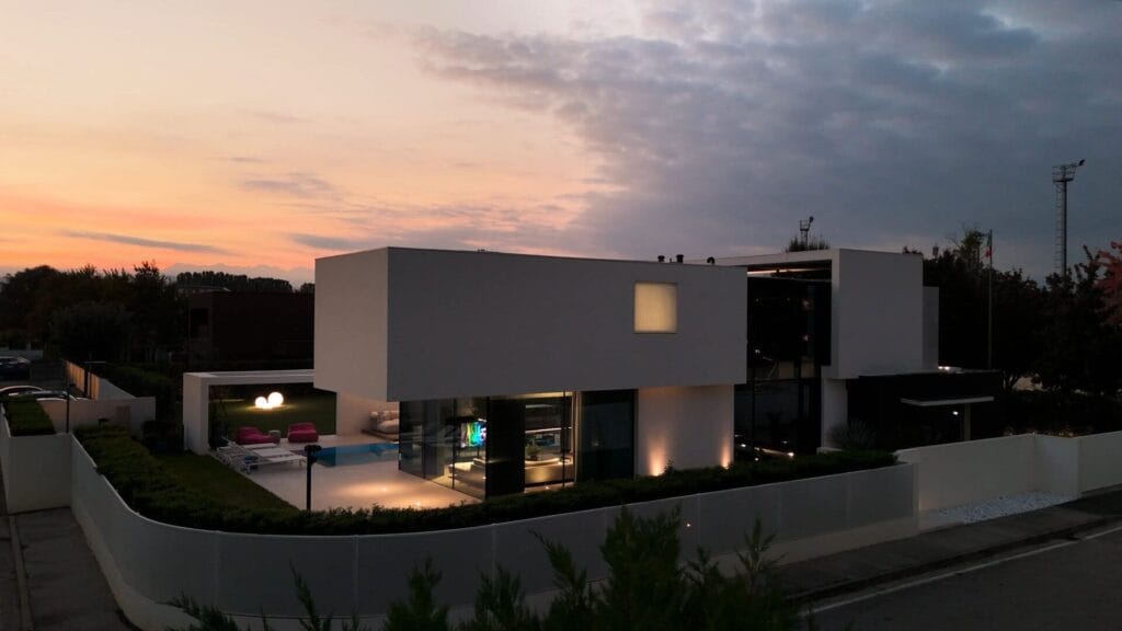
AV Home — Dueville (Vicenza)
Contemporary villa of about 300 m² in Dueville (Vicenza), with an infinity pool, interiors and a private spa. See the project →
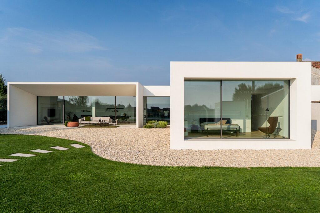
Villa MD Home — Verona
Villa in Verona, 280 m²: white volumes, a black wall, floor-to-ceiling glazing and a pool. See the project →

All studio projects
Villas, interiors and multi-residential projects by the studio: the full list is on the Projects page. See all projects →
Talk to the studio: architect Badia
For information on a plot, a property or a villa project: write to the studio, the answer comes in writing.
or write to info@federicocappellina.com
Architect Badia: villa market in Badia: OMI data
The OMI figures published by the Agenzia delle Entrate (Italian revenue agency) for the second semester of 2025, as reported via recasa.re, provide the reference values for the municipality.
- Ville e villini (villas and small villas), medium value: 7,950 €/sqm, with a zone maximum of 9,700 €/sqm.
- All residential properties, average: 3,478 €/sqm.
- 2024 transactions: residential sales are recorded, including properties over 145 sqm (NTN, the number of transactions).
Data: the figures above are as published in the OMI source. Consequence for the project (studio assessment): the gap between the villa segment and the overall residential average indicates that value in Badia is concentrated in detached and semi-detached houses rather than in the general housing stock.
For a buyer, this makes the quality and legitimacy of the built envelope — volume, materials, energy performance, and above all planning conformity — the variables that most directly affect value. Verification to be made: OMI values are zone-level reference ranges, not valuations of a specific property; a project-specific assessment requires a survey of the individual building and its cadastral and planning position.
Architect Badia: the area of Badia
Badia is a municipality in the Val Badia, in the Dolomites, in the province of Bolzano (South Tyrol). The following data describe the context.
- Resident population: 3,589 inhabitants as of 1 January 2026, indicated as an ISTAT estimate (tuttitalia.it).
- Altitude of the centre: 1,335 m above sea level, referred to the municipal seat (tuttitalia.it).
- Position: Val Badia, Dolomites. The neighbouring municipalities cannot be listed from a reliable source and must be checked (altabadia.org).
- Road distances: one source reports 66.8 km from Alta Badia to Bolzano airport; the distance from the centre of the municipality of Badia cannot be confirmed (rome2rio.com). Reliable road distances from provincial capitals or other main airports cannot be stated.
- Seismic and climate classification: seismic zone 4 and climate zone F, with 4,598 heating degree days (comuniditalia.it).
- Protected areas or Natura 2000 sites within the municipality: not known; the available sources do not allow verification of which areas affect the municipality. This must be checked with the municipality.
Consequence for the project (studio assessment): the altitude of 1,335 m and climate zone F with 4,598 degree days are the governing parameters for envelope design, insulation, glazing and heating systems; they are design inputs, not marketing points. Verification to be made: the exact position of a property relative to the municipal centre, access roads and any protected areas must be confirmed on provincial cartography.
Architect Badia: planning and landscape constraints in Badia
The municipal planning instrument
The municipality of Badia uses a Piano urbanistico comunale (municipal urban plan) — not a PAT/PI or a PGT, the instruments used in other Italian regions. A municipal publication of 2025 states that the re-elaboration of the plan was approved by provincial government resolution no. 4121 of 17 November 2003 and confirmed by the municipal council by resolution no. 77 of 20 December 2013 (municipal notice).
The source does not demonstrate that this is the version in force today, nor does it provide the link to the municipal page dedicated to the plan. Not known: which version is currently in force, or the approval year of any subsequent variant. This must be checked with the municipality.
Landscape constraints
Legislative Decree 42/2004, art. 142, lists areas protected by law, including mountain territories above 1,600 m in the Alpine chain (letter d) and woods and forests (letter g) (Normattiva; summary of landscape constraints). These categories are relevant to verify for the municipal territory, but the available sources do not establish which parcels in Badia actually fall within them.
Art. 142 also covers coastal and lakeside belts; whether any such areas exist in Badia is not known. No source identifies areas in Badia declared of notable public interest under art. 136: not known (Normattiva).
Consequence for the project (studio assessment): where a parcel falls within a protected landscape area, interventions are subject to the authorisation procedures set by law; this does not by itself determine whether a new building is permitted in a specific zone of Badia. Verification to be made: the concrete location of constraints requires the provincial landscape maps and acts applicable to Badia, which the sources found do not identify. Which parcels are constrained is not known and must be checked.
Limits on new construction
Which specific municipal limitations are in force is not known. The municipal act found confirms the existence of the urban plan but does not set out the building rules applicable to new construction (municipal notice).
The general rules of the Code provide that interventions on protected landscape assets are subject to the authorisation procedures set by law, but this alone does not determine whether a new building is admissible in a given zone of Badia (Normattiva). Verification to be made: the zoning of the specific parcel and the building rules of the plan in force must be read directly with the municipality.
Architect Badia: what this means for designing a villa in Badia
The facts set out above have direct consequences for a villa project in the municipality. The points below are the studio’s assessments, tied to the data and sources already cited; they are not statements of what is permitted on any specific plot.
- Altitude and climate (data: municipal seat at 1,335 m; climate zone F with 4,598 degree days, comuniditalia.it). Consequence for the project (studio assessment): a building envelope at this altitude and in this climate zone must be designed around winter performance — insulation, glazing, thermal bridging and heating demand are structural design decisions, not finishing choices. Verification to be made: the applicable provincial energy requirements for new buildings must be confirmed with the competent provincial offices.
- Seismic classification (data: zone 4, same source). Consequence for the project (studio assessment): zone 4 is the lowest seismic category in the national classification, but it is not an exemption; structural design and the related administrative steps still apply and should be planned from the outset. Verification to be made: the structural obligations for the specific intervention must be confirmed with the municipality and the province.
- Landscape constraints (data: D.Lgs. 42/2004, art. 142, letters d and g — mountain territories above 1,600 m in the Alpine chain and woods and forests — normattiva.it). The municipal seat is at 1,335 m, but the municipal territory extends higher, and wooded areas are present in the valley context. Consequence for the project (studio assessment): on a plot that falls within these categories, the design process must assume the landscape authorisation procedure applies, and the siting, volume and external treatment of the villa should be developed with that procedure in mind. Verification to be made: which specific parcels are affected cannot be established from the available sources and must be checked against the provincial landscape cartography and acts.
- Planning instrument (data: the municipality uses a Piano urbanistico comunale; the 2003 provincial approval and 2013 municipal confirmation are documented, but the current version is not confirmed — municipal publication). Consequence for the project (studio assessment): no design assumption can be made until the version of the plan in force for the specific parcel is identified, together with its implementing rules. Verification to be made: the current plan and any subsequent variants must be requested from the municipality.
- Market context (data: OMI medium value for villas 7,950 €/sqm, zone maximum 9,700 €/sqm). Consequence for the project (studio assessment): at this value level, the cost of thorough preliminary checks — planning conformity, landscape status, structural feasibility — is small relative to the value at stake, and skipping them is the main avoidable risk in a purchase.
Architect Badia: checks before buying a plot in Badia
The following checks are specific to this municipality and follow from the sources above. They are listed in the order in which the studio would normally address them.
- Identify the planning instrument in force. Confirm with the municipality which version of the Piano urbanistico comunale applies to the parcel and obtain the relevant zoning map and implementing rules. The 2003/2013 documents cited above do not establish the current version.
- Check the parcel against landscape constraints. Verify whether the plot falls above 1,600 m, whether it includes woods or forest, and whether any other category under art. 142 of D.Lgs. 42/2004 applies. The available sources do not identify which parcels in Badia are affected; this must be checked with the provincial landscape offices and cartography.
- Check for areas of notable public interest. No source identifies specific areas declared under art. 136 of D.Lgs. 42/2004 in Badia; this must be verified with the province.
- Check protected areas and Natura 2000 sites. The available sources do not allow verification of which protected areas interest the municipality; this must be checked with the competent provincial offices.
- Confirm what can be built. The sources do not report the municipal building rules applicable to new construction. Whether a new villa is admissible on the parcel must be confirmed with the municipality before any design work or commitment.
- Verify cadastral and urbanistic conformity of any existing building on the plot, including any volumes that might be relevant to a project.
- Confirm distances and access. Road distances from the municipal centre to Bolzano airport and to other airports cannot be confirmed from reliable sources (the 66.8 km figure refers to Alta Badia, not the municipal centre — rome2rio.com); access and distance should be verified directly.
- Confirm the neighbouring municipalities and any boundary conditions relevant to the parcel; the available sources do not allow a reliable list.
How the studio works
The studio follows a staged process, adapted to the checks and authorisations that apply to each site.
- Stage 1 — Fact base. Collection of the planning, landscape and cadastral documents for the property, with each figure and constraint traced to its source.
- Stage 2 — Feasibility. Assessment of what the applicable rules allow on the specific parcel, with the points that cannot be confirmed flagged for verification with the municipality or province.
- Stage 3 — Concept. Development of the architectural proposal on the confirmed fact base, including envelope performance appropriate to the site’s climate data.
- Stage 4 — Authorisations. Preparation of the applications required by the applicable procedures, including landscape authorisation where the constraints apply.
- Stage 5 — Construction documentation and site phase. Technical drawings, specifications and site support through to completion.
Each stage states what is a documented fact, what is the studio’s assessment, and what remains to be verified.
Do you need an architect Badia for your plot?
Before buying, the studio reads the planning instrument, constraints and indices of the plot with you. Send the location, cadastral references or the listing.
or write to info@federicocappellina.com
Frequently asked questions
When should you involve an architect Badia before buying a plot?
Before signing the preliminary contract. An architect Badia reads the planning instrument, the constraints map and the technical rules that apply to the plot, and lists the checks to request from the municipality and the notary: this is the stage where a mistake costs least.
What does an architect Badia do besides the design?
An architect Badia follows the building and landscape permit, coordinates the consultants (structures, services, geologist) and supervises the works. The stages are described in the section «How the studio works».
How to choose an architect Badia for a villa?
Look at completed projects, knowledge of local planning instruments and the ability to follow the site. The studio’s projects are on the Projects page.
How much does an architect Badia cost for a villa?
An architect Badia’s fee depends on the size of the work, the plot’s constraints and the stages requested (design, permit application, construction drawings, site supervision): it is set in a written quotation after the plot has been analysed.
What should you ask an architect Badia to put in writing before the appointment?
The scope with the stages included, the fee for each, the estimated timing and the list of consultants involved. An architect Badia should also state which checks remain with the client.
Can an architect Badia handle the landscape permit too?
Yes: where the area is subject to a landscape constraint the architect prepares the documentation for the landscape authorisation together with the design; timing depends on the authorities concerned.
How long does an architect Badia need to design a villa?
It depends on complexity and approval times: the design develops in stages and permit timing must be checked with the municipality before a schedule is fixed.
Can you involve an architect Badia before buying the plot?
It is the prudent choice: the architect checks indices, constraints and access on the plot before the purchase, so conditions can be discussed with the seller while the decision is still open.
Do you need an architect Badia for a renovation?
If the work needs a building permit or touches a landscape-protected area, an architect Badia checks which procedure applies with the municipal technical office before any commitment.
What can an architect Badia tell you before an offer on a plot?
An architect Badia can read the planning instrument and the constraints map for the plot and list what must still be verified, so that the offer reflects what can actually be built.
Can I build a new villa on any plot in Badia?
This cannot be answered from the available sources. The municipal building rules applicable to new construction are not reported in the documents found, and admissibility depends on the zoning of the specific parcel. It must be checked with the municipality.
Is the Piano urbanistico comunale of 2003 still the version in force?
The 2003 provincial approval and the 2013 municipal confirmation are documented, but the sources do not establish the current version or any later variant. This must be confirmed with the municipality.
Does the 1,600 m landscape constraint apply to my plot?
The constraint category exists in national law (art. 142, letter d, D.Lgs. 42/2004), but the available sources do not show which parcels in Badia fall within it. The specific parcel must be checked against the provincial landscape cartography.
Are woods on the plot subject to landscape protection?
Woods and forests are a protected category under art. 142, letter g. Whether a specific wooded area on a parcel is affected must be verified with the provincial offices.
What do the OMI values tell me about a specific property?
They are zone-level reference ranges for the municipality, not a valuation of an individual building. A property-specific assessment requires a survey and a review of its planning and cadastral position.
How far is Badia from Bolzano airport?
A source reports 66.8 km from Alta Badia, not from the municipal centre of Badia. A reliable distance from the centre cannot be confirmed from the available sources and should be verified directly.
Which protected areas or Natura 2000 sites are in the municipality?
The available sources do not allow this to be verified. It must be checked with the competent provincial offices.
Architect Badia: contact
For a property in Badia, the first step is establishing the fact base for the specific parcel: the planning instrument in force, the landscape status, and what the municipality confirms can be built. Federico Cappellina Architects can be contacted through the contact page; selected work is published in the projects section.
Architect Badia: glossary of the terms used on this page
OMI
Osservatorio del Mercato Immobiliare: the real-estate market observatory operated by the Italian revenue agency. It publishes periodic reference value ranges for property transactions and rentals, organised by municipality and by homogeneous zone within it. OMI figures are statistical ranges for an area, not valuations of an individual property, and are commonly used as a benchmark for market context.
NTN
Numero di Transazioni Normalizzate: an indicator of the number of real-estate transactions recorded in a given period and area. Each transaction is weighted by the share of the property transferred, so that partial transfers count proportionally. NTN is used to measure market activity and liquidity rather than prices, and is published in official property market statistics.
Planning instrument
The municipal or provincial act that governs land use and building within a territory. It classifies land into zones, sets the rules for permitted interventions, and establishes the procedures for obtaining authorisation. Its name and content vary between Italian regions; the version in force at the time of a project is the one that applies to it.
Landscape constraint
A legal restriction on land or buildings imposed to protect landscape values. It may derive directly from law, which lists categories of protected areas, or from a specific administrative declaration. Where a constraint applies, interventions are subject to the authorisation procedures set by law. Whether a constraint applies to a given parcel must be verified against the competent authority’s maps and acts.
Seismic zone
A classification of Italian territory according to seismic hazard, used to determine the structural design requirements applicable to buildings. Zones are numbered from the highest to the lowest hazard. The classification affects design obligations, verification procedures and the documentation required for construction, and is assigned by the competent regional or provincial authority.
Climate zone
A classification of Italian municipalities based on heating degree days, used to regulate the use of heating systems and to set requirements for building energy performance. Zones are designated by letters, from the mildest to the coldest. The classification is a design input for envelope, insulation, glazing and heating systems.
Building permit
The administrative authorisation required, under Italian building law, for specified categories of construction work, including new buildings and certain substantial interventions on existing ones. It is issued by the competent municipal authority following a technical assessment of the proposal’s conformity with the applicable planning instrument and regulations. The exact title and procedure vary with the type of intervention.
Natura 2000
A European network of protected sites designated for the conservation of habitats and species of community interest, established under European Union nature-conservation directives. Sites are identified and managed by the member states. Interventions affecting a Natura 2000 site are subject to specific assessment procedures; whether a given area falls within the network must be verified with the competent authority.
Landscape authorisation
The administrative act required, under Italian law, for interventions on assets subject to landscape protection. It is issued by the competent authority after assessing the proposal’s compatibility with the protected values. The authorisation is distinct from, and additional to, the building permit, and its necessity depends on whether a landscape constraint actually applies to the property.
Anyone consulting an architect Badia should ask that each glossary entry be tied to the municipality’s official documents rather than to general estimates.
For an architect Badia these terms are the working language: every check on the plot starts here.
An architect Badia explains the meaning of each term to the client before the design is set up.
The definitions are a guide: the detailed check belongs to the technical office and the appointed architect Badia.
Architect Badia: notes for those weighing an appointment
- An architect Badia checks the planning designation of the plot before any volume is hypothesised.
- An architect Badia asks the municipality for the certification of the constraints that affect the area.
Architect Badia: ask the studio for information
For a villa project or a plot consultation: tell us the municipality, the area and your starting ideas. Direct contact with the architect, in writing.
or write to info@federicocappellina.com